
 01 / 01
GARMIN
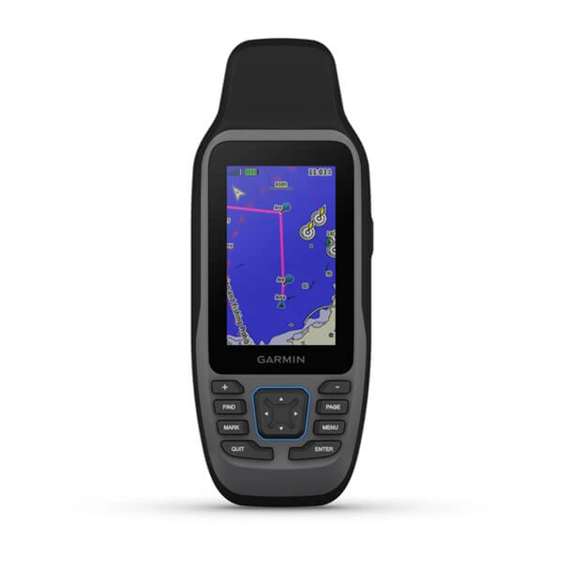
GPSMAP® 79s
FLOATABLE MARINE HANDHELD MULTI-GNSSRugged, floatable marine handheld GPS featuring a sunlight-readable 3-inch color display, chemically strengthened scratch-resistant glass, multi-GNSS constellation support, 3-axis tilt-compensated electronic compass, worldwide basemap, 8 GB memory, and up to 19 hours of battery life for marine, defense, and coastal survey operations.
Display3.0-inch transflective 65K color TFT (240 x 400 pixels), sunlight-readable, chemically strengthened glass
Buoyancy & IngressFloats in water; IPX7 waterproof rating (withstands immersion to 1 meter for 30 minutes)
Configuration, availability and delivery confirmed with your quotation.
01 / FIELD CAPABILITIES
Built for the task.
- Floatable buoyant construction ensures the device stays afloat and undamaged if dropped overboard into open water
- Sunlight-readable 3.0-inch color display features chemically strengthened scratch-resistant and fogproof glass for harsh marine environments
- Multi-GNSS constellation tracking accesses GPS, GLONASS, Galileo, QZSS, and BeiDou for dependable maritime and coastal positioning
- Built-in 3-axis tilt-compensated electronic compass delivers accurate orientation headings even while vessel is idling or drifting
- Internal 8 GB storage with microSD card expansion allows loading of specialized nautical charts and coastal mapping
- Up to 19 hours of continuous navigation stamina powered by two standard field-replaceable AA batteries
- Built to MIL-STD-810 standards with IPX7 waterproofing for dependable performance in heavy surf, spray, and torrential rain
02 / TECHNICAL DETAILS
Precision, specified.
- Display
- 3.0-inch transflective 65K color TFT (240 x 400 pixels), sunlight-readable, chemically strengthened glass
- Buoyancy & Ingress
- Floats in water; IPX7 waterproof rating (withstands immersion to 1 meter for 30 minutes)
- Durability Standards
- MIL-STD-810 tested for thermal shock and vibration resistance; fogproof bonded display
- Satellite Constellations
- Multi-GNSS: GPS, GLONASS, Galileo, QZSS, BeiDou, and SBAS
- Electronic Compass
- Built-in 3-axis tilt-compensated electronic compass (accurate bearing while drifting or stationary)
- Preloaded Basemap
- Worldwide basemap with support for optional BlueChart® g3 marine charts
- Memory & Storage
- 8 GB internal memory; microSD™ card slot (supports up to 32 GB)
- Battery Type
- 2 AA batteries (NiMH or Lithium recommended; field replaceable)
- Battery Autonomy
- Up to 19 hours in standard GPS mode
- Waypoints & Memory
- 10,000 waypoints / 250 routes / 250 saved tracks (20,000 track log points)
- Interface
- High-speed micro USB and NMEA 0183 compatible
- Dimensions (W x H x D)
- 6.77 x 17.40 x 4.23 cm (2.67" x 6.85" x 1.67")
- Weight
- 282 g (9.95 oz) with AA batteries
- Field Navigation Tools
- Area calculation, MOB mode, marine alarms (anchor drag, arrival, off-course), celestial tables, custom POIs
Key specifications and field-use details. Exact configuration may vary by model or selected variant.
Garmin
Find your position and your next destination with purpose-built handheld navigation.
CONTINUE YOUR EXPLORATION
All products COMPLETE YOUR FIELD KIT.
YOUR NEXT EXPEDITION STARTS HEREBig terrain.
Big terrain.
Bigger possibilities.
Tell us where you're headed.
We'll help you get equipped.